


TECHNOLOGY OF GLOBALIZATION
Views: 4447
The innovative potential of the Kazakhstani economy can be increased only through the construction of an effective scientific and innovative system, the basis of which will be powerful research universities and innovation clusters. Developing this strategic concept, the head of state Kassym-Jomart Tokayev set the goal of forming science and education as separate sectors of the economy. In accordance with the tasks set by the Head of State for the further socio-economic development of the country, Al-Farabi KazNU implements projects using modern technologies aimed at improving the welfare of the country's society and building an innovative competitive economy as a whole.
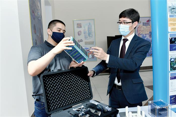
One of these developments is the innovative designers of small artificial earth satellites "ALFASAT", designed to teach schoolchildren and students the basics of developing, designing, assembling, testing and operating a spacecraft. When working with the constructor, students develop not only Hard Skills, but also Soft Skills. Thanks to the study of the material in a team, users gain in-depth knowledge of the design of a real spacecraft. Each student will be able to assemble his own nanosatellite and launch it into the stratosphere using a helium balloon.
Specialists of the Al-Farabi Kazakh National University have created new projects that help increase the potential of the country's economy. The goal of the project is to manufacture and market a HIL simulation device designed to teach schoolchildren and students the basics of developing, designing, assembling, testing and operating a spacecraft with appropriate software and teaching materials.
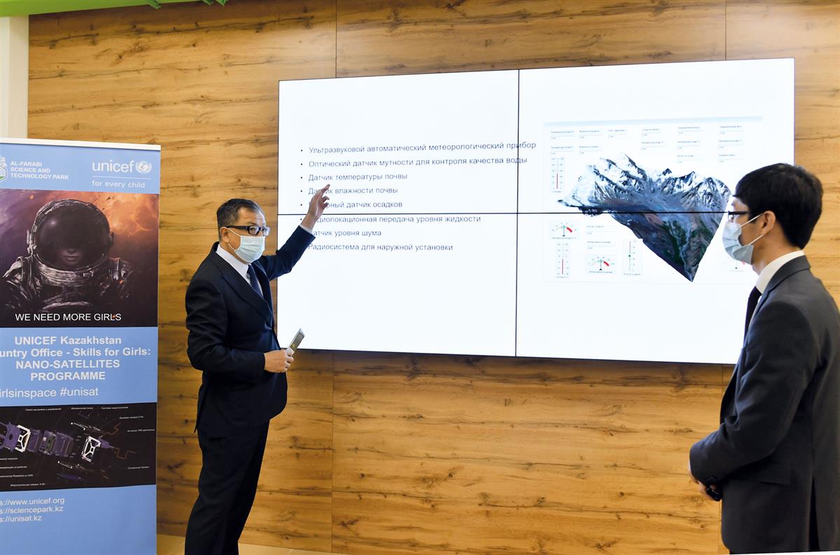
Since 2018, the Center for Space Technologies and Remote Sensing of the Earth (CKTiRSZ) of the University has been preparing geoproducts (electronic maps, Web GIS portals, intelligent user interfaces and developers of geographic information systems, tablets and plan-schemes of spatial objects, etc.) for various industries on on the basis of geoinformation technologies and space remote sensing data of the Earth. Cartographic, statistical and weather data from other sources are also used. This system is an indispensable approach for making significant changes in many sectors of the country's economy. This is especially beneficial for industries such as agriculture, construction, emergency situations, ecology, environmental protection and freight and passenger transportation. Such innovative products directly contribute to global competitiveness.
According to Omirzhan Taukebaev, Deputy General Director of the Engineering and Science-Intensive Technologies Cluster of the University, the main activity of this center is the acquisition, processing and distribution of satellite images of various spatial resolutions. Monitoring various analytical work using such information.
In 2019, Al-Farabi KazNU signed a partnership agreement with SuperMap. In accordance with this agreement, the university was granted the right to distribute, train and provide technical support for the implementation of applications of the SuperMap GIS software platform in Central Asia. SuperMap Software Co., Ltd is the world's largest GIS platform company and has over 1000 partners worldwide, such as HUAWei, IBM, Microsoft.
A virtual receiving space station SatSee of the Chinese Academy of Sciences was installed at the CT&RSD Center. This makes it possible to obtain images of the desired territory in the QuickLook mode from five artificial remote sensing satellites of the PRC, the USA, observing the flight paths of spacecraft. That is, the abundance of spacecraft creates favorable conditions for obtaining data with a faster and more frequent interval compared to the existing Kazakhstan space remote sensing systems. Today, the CT&RSD Center not only probes the Earth's surface, but also conducts internships for university students and undergraduates.
– In the 2020-2021 academic year, the CT&RSD Center together with SuperMap installed 30 licenses of the SuperMap iDesktop program for the following university departments: the Department of Cartography and Geoinformatics, the Department of Geography, Land Management and Cadastre and the Department of Mechanics. Also, on the basis of the Department of Cartography and Geoinformatics, a laboratory of "Geoinformation Cartography" was opened on the basis of innovative products from SuperMap. This program complies with all standards all over the world, and the main difference is that it can work on platforms such as Big Data, artificial intelligence and 3D GIS, which are considered a modern trend. Another point worth paying attention to is that the program has the ability to make more than 600 analyzes, Omirzhan Taukebaev noted.
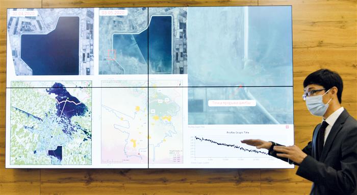
According to Omirzhan Zhalgasbekovich, in 2020, during the breakthrough of the Sardoba reservoir, the KTiDZZ Center, together with specialists from the Institute of Aerospace Research under the Chinese Academy of Sciences, conducted a study. On the basis of GF-3 space images, the area of flooding of crop fields and settlements was determined and analyzed in the shortest possible time.
- Then, together with specialists from the Institute of Aerospace Research under the Chinese Academy of Sciences, based on satellite images, we established that the width of the dam breakthrough is 234 meters. When we analyzed using a digital elevation model, it turned out that the distance from the Sardoba reservoir to the territory of Kazakhstan was 25-30 kilometers, the mudflow went down the slope. “For example, the reservoir is located at an altitude of about 287 meters above sea level, then the level of the flooded zones was lower by 210-215 meters,” says Omirzhan Taukebaev.
In the hot months in the foothill areas, moraine lakes pose a serious threat. Moraine lakes are not always a constant phenomenon, and therefore monitoring of the situation is essential. According to experts, any such lake can carry a potential danger: a breakthrough can occur both through a jumper, that is, as a result of water overflowing over the edge, and through the wall of the lake, which does not always consist only of soil, but may contain a glacier inside. Its melting weakens the stability of the wall and, due to water pressure, it can be shed.
– At present, the KTiRSZ Center is planning to create an automated monitoring system for moraine lakes and create container-type mobile hybrid power plants. There are 945 moraine lakes in Kazakhstan, 47 of them are dangerous. There are 36 moraine lakes in the vicinity of the city of Almaty, 14 of them are dangerous. At the same time, mudflow and avalanche zones of the country need constant monitoring. The use of space technologies will make it possible to prevent disasters caused by natural and anthropogenic factors and reduce the amount of damage. And an automated intelligent system can measure several indicators simultaneously. For example, determine the quality of water, temperature and soil moisture, rainfall. And specialists, sitting in situational centers, analyze these data. In addition, the installation of 360-degree cameras will make it possible to keep the situation under full control,” Omirzhan Taukebaev said.
The Earth Remote Sensing Center provides space monitoring services in the following areas:
- analysis of the consequences of forest and steppe fires;
- analysis of the consequences of mudflows and floods;
- mapping and analysis of the state of livestock pastures;
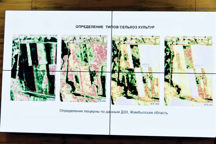
- mapping and analysis of crop areas;
- analysis of the state of household waste disposal facilities;
- definition of new construction objects and changes in urban areas;
- creation, implementation of Web-GIS portal (geoportal) and publication of electronic maps and semantic information on the geoportal.
The CT&DZZ Center also contributes to the development of the tourism sector. For example, last year, in order to develop tourism, specialists from the KTiDZZ Center together with Turanga Group LLP prepared an electronic map and a plan for tourists. The map shows three trails and tourist sites in the Ayusai Gorge, located in the Ile-Alatau National Park. Also, tourists have access to information about the length and complexity of the trails. In the future, it is planned to prepare an application for a smartphone and create a geoportal. Since all this data is in digital format, it is very easy to edit it. Therefore, when improving the infrastructure, the map can be supplemented with new data at any time.
- There is one more point that can be useful to local executive bodies, - says Omirzhan Zhalgasbekovich. – For example, with the help of satellite images, monitoring of household waste disposal sites has become available. The landfill near Almaty is located near the village of Aytey. The volume of waste on it over the past decade has increased by 2.5 times. This method creates conditions for the detection of unauthorized dumps and unburied municipal solid waste. This project also aims to prevent any environmental problems.
Thus, the use of geographic information system data and remote sensing data has led to significant changes in the era of globalization. The developed countries of the world are effectively using such technologies and have achieved concrete results.
Kairzhan TUREZHANOV